Solving the Affordability Paradox
How to transform "Luxury Nodes" into equitable networks by integrating transit with critical housing infrastructure

I believe in the value of public transportation. As a full-time engineer, I worked on several major projects that could have changed the tri-state area, but many were delayed or canceled due to high costs and local opposition. With gas prices rising, we need to decide whether to keep depending on cars, ICE or EV, or start building a better public transportation system. I vote for the latter.
The Tale of Two Urban Paradigms
I’m not an urban planner, but as a civil engineer who worked in Transportation, I’ve met a few of them. On top of that, I use public transit and walk like most people. When I take a bus to Port Authority or leave an airport, I notice how well a city is organized, or sometimes how it falls short. The saying, “you can’t get there from here,” really does apply to many places in the US.
Imagine Jane Commuter, who works in Jersey City, NJ, but lives in the suburbs. She likes her single-family home on a quiet street. With no train or light rail nearby, she drives to work, leaving early to handle traffic on Route 3 and 1&9. Her commute takes about an hour. Once she arrives, she pays for parking and walks to her office for 10 minutes. After work, she repeats the process, dealing with more traffic on the way home. Jane doesn’t mind the hour-long commute; she listens to audiobooks and stops at the grocery store before heading home.
Now, consider Nico Commuter in Butzbach, Germany. Nico lives in an apartment above a bakery. He takes the commuter rail to his office in Frankfurt, with the train station just a ten-minute walk from his home along a cobblestone plaza. His commute also takes about an hour, like Jane’s, but he doesn’t pay for parking. He just walks from the train station to his office, another ten-minute walk. After work, he picks up groceries for dinner and heads back to the station. He listens to audiobooks on his way home, too.
I’ve spent most of my life in New Jersey, so I know what commutes like Jane’s are like, and I also know people like Nico (their names and locations have been changed). Their daily routines are very different, and these differences affect sustainability and accessibility.
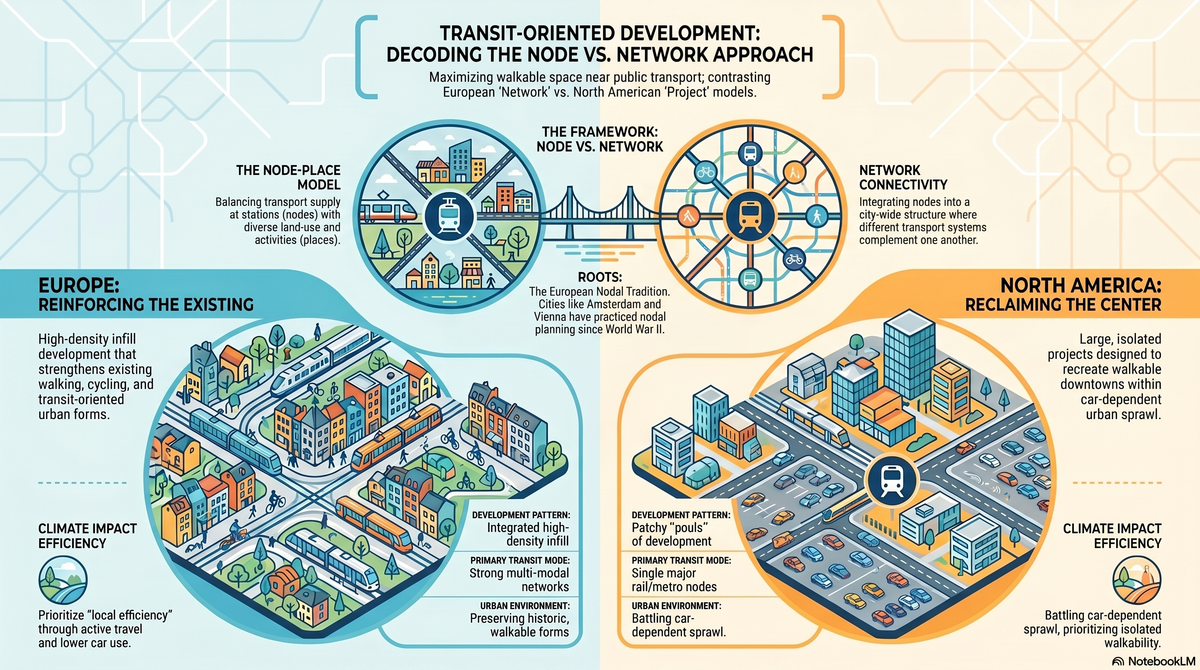
The main difference comes from how cities and suburbs were built in the US and Europe. In the US, most places are designed for cars, and public transit is often disconnected. When cities try to make areas more transit-friendly, they use Transit Oriented Development (TOD). This approach, known as the node model, puts a train or bus station at the center with parking lots, then adds homes and businesses nearby. People who live close can walk, but those farther away still have to drive. Parking lots also use up valuable space and keep the focus on cars.
Europe takes a broader approach, building regional networks rather than isolated hubs. The aim is to create a web of walkable streets and transit options. You don’t need a car for errands or work; you can usually walk to a transit station within fifteen minutes and get wherever you need to go.
Both methods aim to bring more people and activity to local areas without relying on cars. We don’t have to choose just one. Instead, we can combine the best parts of each and adapt them for life in the United States.
The American Approach – The “Surgical” Transit Node
In the early 1990s, urban designer Peter Calthorpe introduced Transit-Oriented Development (TOD) as a way to fight suburban sprawl in America (Carlton, 2009, pp. 315-335). His idea focused on the “pedestrian pocket”: a high-density, mixed-use area within a quarter to half a mile (about a ten-minute walk) of a transit station (Loutzenheiser, 1997, pp. 6-14).
By keeping daily life within this 400-to-800-meter zone, TOD aimed to solve the “last mile” problem and create a walkable, self-contained neighborhood instead of just a commuter stop (III et al., 2022). Orenco, Oregon, is a leading example of this idea in action. Many see it as a North American success story. Orenco showed that even in spread-out areas, good design can change how people get around. By mixing different types of housing, great public spaces, and shops right at the light-rail stop, it proved that people will choose walking over driving if the neighborhood is well planned. Orenco is still seen as proof that suburbs can be both dense and appealing.
But this model has a major limitation, called the “Transit Island” effect. Projects like Orenco work well inside their own boundaries, but are often surrounded by car-focused development that isn’t friendly to walking or biking. Because these places are built as isolated spots rather than as part of a larger network, they usually don’t lead to a larger shift away from cars, as the European model does. Until we connect the spaces between these nodes, TODs will remain walkable bubbles surrounded by parking lots and roads.
The European Paradigm – The Continuous Urban Web
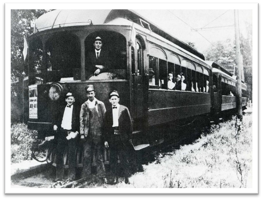
The differences between North American and European city planning stem from their distinct histories. In the mid-1900s, North American cities rapidly changed to accommodate cars, removing streetcar lines and tearing down city centers to build highways (A Streetcar City, n.d.). In Bergen County, where I grew up, there was once a streetcar that connected small towns to bigger railroads. The old New Jersey Rapid Transit Right-of-Way is still there, and you can walk from Ridgewood to Waldwick, NJ, along it.
European cities, by contrast, maintained their compact layouts through strict land-use rules and the protection of historic buildings.
Because these mixed-use, walkable neighborhoods were never lost, European planners rarely use the term “Transit-Oriented Development” today. In Europe, things like density, walkability, and being close to transit aren’t special projects; they’re just the standard way of planning cities.
A good example of this European approach is Copenhagen’s 1947 Finger Plan. Planners pictured the city as a hand, with the old city center as the “palm” and five commuter rail lines as the “fingers.” The areas between these fingers were kept as permanent green spaces for farming, nature, and recreation. Instead of just stopping growth, the Finger Plan guided it, creating a network-based model that ensures new suburbs are always connected to public transit (Fingerplanen: Danmarks første byudviklingsplan for Storkøbenhavn, 2019).
The European model also operates on a larger scale through a concept called polycentricity. Instead of having one big downtown with suburbs that depend on it, European planning often connects several small and medium-sized cities. These city clusters support each other and spread jobs and services across a wider area. The Dutch Randstad is a good example: cities like Amsterdam, Rotterdam, The Hague, and Utrecht form a ring, linked by frequent trains, making it easy to travel anywhere in the region as if it were one big city (Priemus, 1998, pp. 443-455).
The Topology of Efficiency – Hub-and-Spoke vs. The Mesh
The traditional North American transit system mostly uses the Hub-and-Spoke model. This setup channels riders from suburban “spokes” into a single, busy “hub,” usually the Central Business District (CBD). While this makes commuting to work efficient, it also creates major bottlenecks. Because the system is built mainly for trips in and out of the center, traveling between suburbs or across the city without going through downtown is often impossible or very slow. This design makes transit good for commuting, but not for flexible, all-day travel (O’Kelly, 1998, pp. 171-186).
In contrast, the European model often uses a Mesh Network, or grid, approach. Instead of sending all trips through a single central point, a mesh offers many intersections and multiple routes between places. In a strong mesh, people can travel north-south or east-west across the city just as easily, often skipping the city center. This setup moves away from a “radial” mindset and prioritizes mobility.
With a web of connected lines, the city offers many options, so the shortest route between two places doesn’t always mean going through downtown (Evolution of Transportation and Urban Form in North America and Europe, 2017).
The real strength of the mesh is what’s called the “Explosion of Usefulness.” This means that a dense grid of frequent transit lines boosts accessibility much more than just adding a single new route. When lines are frequent and cross each other often, every new line increases the value of the whole network by creating more transfer options.
Suddenly, every line becomes a way to reach any point on another line. This kind of network turns separate bus and train routes into a single, flexible system, letting riders reach many destinations in about the same amount of time (Wu et al., 2019).
The Dark Side of the Node (Equity & Gentrification)
In North America, the high cost of Transit-Oriented Development comes from artificial scarcity. Walkable, transit-rich areas are so rare in car-focused regions that they become “luxury goods.” This drives up land values, as people want to live without needing a car. When a new TOD is built in a low-density area, it doesn’t just add housing; it creates a high-demand spot that takes a large share of regional value. Urban theorists call this the rent gap, the difference between what land is worth now and what it could be worth with more transit-oriented use.
This economic boom leads to the Affordability Paradox: the people who need public transit most, like low-income families and service workers, are often pushed out by rising prices after a new TOD is built. It’s a sad irony to build great transit access but surround it with housing that those riders can’t afford.
At Orenco Station, for example, the extra cost for walkability is clear: home prices have stayed 20% to 30% above the Washington County average. This pricing keeps out the people who would use transit most and attracts wealthier residents who may still own several cars. Without strong affordable housing policies, such as inclusionary zoning, community land trusts, or subsidized “workforce” housing, the TOD becomes a gated community with a train platform.
To move from a “luxury node” to a real “equity network,” planners must treat affordable housing as critical infrastructure, just as important as the tracks or the station itself. True sustainability means the people who need the network can actually live within it.
The “Node-Place Model” – The Ultimate Balancing Act
To move beyond just observing, we can use Luca Bertolini’s “Node-Place Model.” Developed in the late 1990s, this model helps urban planners understand why some transit stations become lively communities while others remain empty and dull (Bertolini, 1999, pp. 199-210). By mapping each station on a two-dimensional grid, the model helps us see “transit” and “development” as two parts of the same whole, not separate issues.
At its core, every station has two sides: it’s both a Node and a Place. The “Node” is about how well the station moves people; how many people it serves; how often trains or buses arrive; and how well it connects to the wider network. The “Place” is about the mix and number of things people can do nearby. A great “Place” isn’t just a tall apartment building; it’s a mix of libraries, grocery stores, offices, and parks that give people reasons to be there without needing to get on a train (Olaru et al., 2019).
Finding the “Sweet Spot” means understanding four main categories in the model. A station is Balanced when its transport capacity matches the amount built around it. If both are very high, the station is in Stress—an intense, crowded place where space is in high demand, like Midtown Manhattan or Central London. The real problems are the “Unbalanced” cases. An Unbalanced Node is a wasted resource, like a high-speed rail stop surrounded by parking lots. An Unbalanced Place is the suburban nightmare: lots of development but not enough transit, which leads to traffic jams and car dependence.
The future of planning can be seen in “Vancouverism,” which blends the isolated American node with the broad European network. By mixing high-density housing with fast, grade-separated transit like the SkyTrain, Vancouver set an example for lively cities (Vancouverism, 2024).
The key lesson is that we don’t have to choose between a “Transit Island” and a “Sprawling Network.” Instead, we can use these dense, efficient nodes as engines for a broader, connected mesh, providing both walkable neighborhoods and fast regional travel.
To make this work, our future plans need to be technically strong. First, network speed is essential; transit can’t compete with cars unless it’s frequent and grade-separated, like the automated SkyTrain, rather than street-level light rail that gets stuck in traffic. Second, we need to connect these islands by linking every high-density TOD into a regional mesh, making sure that “walkable density” is a standard for everyone, not just a luxury.
Finally, we need to include affordability from the start. To avoid the “Affordability Paradox,” missing-middle and social housing should be built into transit corridors, so the network stays open to the people who need it most.
Ultimately, the decision for how to make better, walkable, and sustainable cities and living environments is not up to planners, engineers, architects, and public transportation agencies - we can only recommend and design what they could look like. The decision to build public transportation and a better way of life is up to the voting public and their desire to put their tax dollars to shape a different way of getting around.
References
Carlton, Ian. “Histories of Transit-Oriented Development: Perspectives on the Development of the TOD Concept.” International Journal of Urban and Regional Research, vol. 33, no. 1, 2009, pp. 315-335. https://www.econstor.eu/bitstream/10419/59412/1/609256262.pdf
Loutzenheiser, David R.. “Pedestrian Access to Transit: Model of Walk Trips and Their Design and Urban Form Determinants Around Bay Area Rapid Transit Stations.” Transportation Research Record: Journal of the Transportation Research Board, vol. 1604, no. 1, 1997, pp. 6-14. https://journals.sagepub.com/doi/10.3141/1604-06
III, William P. Rogers, et al. “Beyond Traditional TOD: Integrating Multiuse Paths and Bike Share into Public Transit to Address the First/Last Mile Issue.” Urban Rail Transit, vol. 9, 2022. https://link.springer.com/article/10.1007/s40864-022-00182-x
“A Streetcar City.” National Museum of American History. https://americanhistory.si.edu/explore/exhibitions/america-on-the-move/online/streetcar-city Accessed May 11, 2026
“Fingerplanen: Danmarks første byudviklingsplan for Storkøbenhavn.” Dansk Arkitektur Center, 2019. https://dac.dk/magazine/fingerplanen-danmarks-forste-byudviklingsplan-for-storkobenhavn Accessed May 11, 2026
Priemus, Hugo. “The Randstad and the Central Netherlands urban ring: Planners waver between two concepts.” European Planning Studies, vol. 6, no. 4, 1998, pp. 443-455. https://www.tandfonline.com/doi/abs/10.1080/09654319808720473
O’Kelly, Morton E.. “A Geographer’s Analysis of Hub-and-Spoke Networks.” Journal of Transport Geography, vol. 6, no. 3, 1998, pp. 171-186. https://www.sciencedirect.com/science/article/abs/pii/S0966692398000106?via%3Dihub
“Evolution of Transportation and Urban Form in North America and Europe.” The Geography of Transport Systems, 2017. https://transportgeography.org/contents/chapter8/transportation-urban-form/evolution-transport-urban-form/ Accessed May 11, 2026
Wu, Hao, et al. “How transit scaling shapes cities.” Nature Sustainability, vol. 2, 2019. https://www.nature.com/articles/s41893-019-0427-7
Bertolini, Luca. “Spatial Development Patterns and Public Transport: The Application of an Analytical Model in the Netherlands.” Planning Practice and Research, vol. 14, no. 2, 1999, pp. 199-210. https://www.tandfonline.com/doi/abs/10.1080/02697459915724
Olaru, Doina, et al. “Place vs. Node Transit: Planning Policies Revisited.” Sustainability, vol. 11, no. 2, 2019. https://www.mdpi.com/2071-1050/11/2/477
“Vancouverism.” Wikipedia, 2024. https://en.wikipedia.org/wiki/Vancouverism Accessed May 11, 2026